Flood History Facts ... Greater Ocean Shores Flood Prevention Task Force
Marshalls
Creek
Floodplain Review
Natural
& Man-made
Outlets - Obstructions
1947
Coastal
View from
NB to Wooyung
1954
Helen
St
South Golden Beach
1958
Construction
of
South Golden Beach
1972
Helen
St Blowout
South Golden Beach
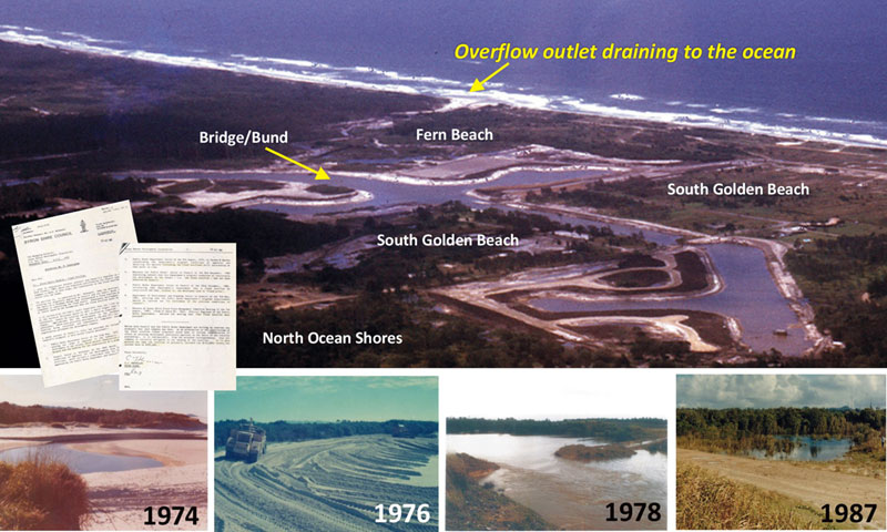
1974
North
Ocean Shores
Overflow OPEN
1976
North
Ocean Shores
Overflow CLOSED
1980
North
Ocean Shores
Outlets Closed
1987
North
Ocean Shores
Outlet still CLOSED
1997
Re-vegetation
New Brighton Overflow
2007
Lazer
Aerial Map
showing AHD levels
INVESTIGATION:
Deed of Agreement for the construction of the Ocean Shores Estate
Mother's Day Nine News Story 1987
Task: To investigate and affirm that the documents and historical timeline facts in relation to the establishment of the Ocean Shores Estate, are true and correct.
Background to the Deed of Agreement:
Background supplied by Jan Mangleson President of OSCA Inc.The Ocean Shores Community Association (OSCA) began in the early days of the estate’s formation. Three years ago, OSCA celebrated fifty years since the opening of the Ocean Shores Administration Centre (The Roundhouse) on March 29, 1969 by the Hon. S. T. Stephens, Minister for Housing and Co-Operative Societies. Shortly after came the signing of the Ocean Shores’ Deed of Agreement. This is the founding document of the town. It outlined an agreement with the NSW State Government, Byron Council, Rous County Council (water), the Municipality of Mullumbimby (electricity provider) the owners of the dairy farms who sold their properties and Wendell West Australia Pty Ltd (the developer). Over a period of 25 years the town was to be developed in three stages.Wendell West sold its Australian interests to Princess Properties Pty. Ltd who took over as the developer of the project.
Stage 1 included the Roundhouse, golf course, country club, Orana Apartments, Orana Bridge, small shopping centre and residential development.
Stage 2, centred around the Capricornia Canal, was constructed by Princess Properties and completed by the Bond Corporation.Stage 3 was never built and became the Billinudgel Nature Reserve following environmental activism from local groups. Intended for Stage 3 was a civic centre, high school, three primary schools, sports fields, regional shopping centre, town centre, surf club and more.
The Roundhouse was demolished by Byron Council when it bought the property. The council subsequently developed and sold the site as 11 large residential blocks.
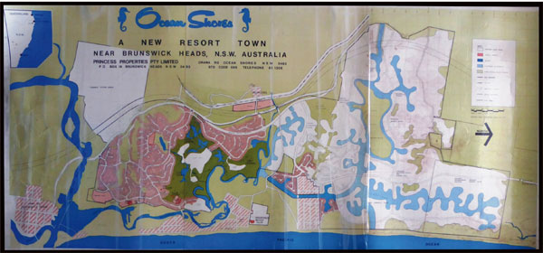
The Strategic Plan for the Development:In the Princess Properties map dated January 17, 1973, strategic plan showing essential development elements which included a 2 primary schools, a high school and sportsfields, a commercial centre, an ocean outlet for the Capricornia Canal and Marshall's Creek, Shara Boulevarde to extend the highway through the north of the town to Wooyung Road and the Wooyung school, 3 reserves for public recreation, a beach club, many kiliometres of ocean beach, two bridges, a large area set aside for nature reserve.
The 1975 Real Estate Map of the Stage 1, Stage 2 and the Stage 3 Ocean Shores Development - click here
Note: click here for the summary of events printed in The Shores Magazine circa 1995.
There is mention of the Deed of Agreement which stated on p 8 'The original development was covered by a deed of agreement between the government and the development company which bonded various issues including the flood outlet before the land was allowed to be developed or sold.'Glossery of Terms:
Compliance - is the state of being in accordance with established guidelines or specifications, or the process of becoming so.
A Deed of Agreement - is a special type of legally binding promise or a commitment to do something._________________________________________________________________________________
DRAFT Questions 1 - 10 for
Proposed Framework for Investigation Purposes
Development of Stage 2 North Ocean Shores;Question 1 :
Is Byron Shire Council aware that the North Ocean Shores flood overflow outlet and the proposed Capricornia bridge was covered by a Deed of Agreement?COMMENT for discussion: A bond was to be paid to Council (letter Shire Clerk S.C Shevellar viewpoints 1-7) to rectify the effect of flooding due to the closure of the temporary flood overflow near South Gloden Beach. The bond money was to be used for the construction and maintenance of a permanent Ocean Outfall at North Ocean Shores.
Note: Byron Shire Engineer Mr Greg Alderson confirms in a letter that the outlet would make a “significant” difference in flood heights.
_________________________________________________________________________________
Question 2 :
Why did Stage 3 of Ocean Shores not proceed?Future plans were tabled for Stage 3 of the development of Ocean Shores . This Stage 3 was to be undertaken in the area north of South Golden Beach around and including where the ocean outlet existed.
COMMENT for discussion: On the question of Bonding by Council, the original developers of the Ocean Shores Estate were ordered by a Deed of Agreement to bond large amounts of money. This was in the order of $130,000 of $295,000 to complete outstanding flood outlet which was a condition of consent for the project.
Byron Shire Council has steadfastly refused to honour that commitment but have had control of the Bond money since 1969.
The calculation at 2% per annum is conservative during that period. Other flood reduction works were carried out by the adjoining Tweed Council to drain flood waters from Tweed cane fields north of Ocean Shores into Ocean Shores through the Capricornia Canal at no cost to Council. All of this is clearly evident on public documentation with and many warnings from previous Governments of Council's liability for causing the flooding.
Clearly the monies would be considerable after 60 plus years.
_________________________________________________________________________________
Question 3 :
What would be the amount of money in interest, accumulated by that bond since 1969?
COMMENT for discussion: Former Council Engineer Mr Greg Alderson threatened to use that money when a bridge was not built over the Capricornia Canal.Note: The only remedial works to date have been for residents based at South Golden Beach with Government funding to build a levee and to remove the flood water from South Golden Beach into Capricornia Canal via a flood pump.
_________________________________________________________________________________
Question 4 :
Why did Council close the overflow outlet at North Ocean Shores without fulfilling their obligation to address flood mitigation on the floodplain? Was there any connnection to the Billinudgel Nature Reserve having wetland status? Who was responsible in making the Billinudgel Nature Reserve a wetland?WETLAND STATUS REMOVED IN 1987:
PRESS RELEASE July 1, 1987
from the then Minister for Planning and Environment Mr Bob Carr.
'Carr removes wetland status'
The following statement was backed up by a spokeman for Mr Carr who said a recent revision had shown that 33 hectares of the land was non-wetland cypress pine and old marsh pastures.
"It never really was wetlands and shouldn't have been included in the policy in the first place."
Full Newspaper Article from the Sydney Morning Herald July 1987COMMENT for discussion: There is a solution to the flooding problem which is not harmful to the environment. Hoping Council will listen to the people who have already been harmed by the neglect to act. There is a 'duty of care' for Council to protect the residents from studies and policies that may have been based on misinformation.
_________________________________________________________________________________
LOCAL LOBBY & CONSERVATION GROUP:
Conservation of North Ocean Shores (C.O.N.O.S.) involvement in the region of North Ocean Shores/Yelgun.Background: p2 CONOS Submission
Conservation of North Ocean Shores was established in 1992. The group’s main objective has been to protect the natural and cultural values of the lowland coastal ecological communities in the north of Byron Shire. CONOS was instrumental in the establishment of the Marshalls Creek & Billinudgel Nature Reserves.click here for map of Billinudgel Nature Reserve 2000
Note: CONOS objected to the Application No: SSD 8169 and MP 09_0028 MOD 3 for the North Byron Parklands Festival Site gaining permanent approval.
click here for full document (Objection to North Byron Parklands Festival Site Development)
Measures taken by NSW Government in Protecting the North Ocean Shores/Yelgun Site
Compiled by Conservation of North Ocean Shores (CONOS)
1985 SEPP 14 Wetlands No. 57 gazetted by NSW Dept. of Planning.1987 NSW Labor Minister for Planning & Environment places Interim
Conservation Order (ICO) over lands at North Ocean Shores / Yelgun following the
bulldozing of culturally significant coastal lands.1989 Large areas of North Ocean Shores / Yelgun Referenced by NPWS.
N.B. Only areas of high conservation value meet this criteria.1990 Commission of Inquiry (COI) into Rezoning of Lands at Ocean Shores,
North. Commissioner Simpson recommends the majority of lands be zoned
for environmental protection due to the areas natural and cultural values..... to 2009.
Check Note:
1. North Byron Parklands gifted lands which adds to the Billinudgel Nature Reserve total area.
PRESS RELEASE March 20, 2020
click here for the ECHO Newspaper article.
Extract from Article: Over 37.15ha of ecologically significant land has been gifted to the Billinudgel Nature Reserve by North Byron Parklands. Parklands general manager Mat Morris said, ‘More than 14 per cent of Parklands’ 256ha has been dedicated to National Parks and Wildlife Service (NPWS)._________________________________________________________________________________
PRESS RELEASE September 2, 1995
COMMENT for discussion: Ocean outlets in the options to ease flooding.
Full Newspaper Article from the Northern Star September 1995_________________________________________________________________________________
BACKGROUND INFORMATION:
Billinudgel Nature Reserve - April 1996
A core area of 357 hectares was dedicated, pursuant to the NP&W Act, as a nature reserve in April 1996. Two areas of 189.5 hectares and 166.6 hectares were purchased in late 1996 and dedicated as an addition to the Reserve in 1997. The total area of the Reserve is now approximately 713 hectares.Billinudgel Nature Reserve Plan of Management 2000
click here to access BNR Management Plan 2000Acknowledgments:
taken from the Billinudgel Nature Reserve Plan of Management November, 2000.
The draft plan of management for Billinudgel Nature Reserve was prepared by Jane Baldwin, now Community Relations Ranger, North Coast Region, and this adopted plan of management was prepared by Graeme McGregor, Planning Officer, Northern Rivers Region.
Valuable input has been provided by
Val and Stan Scanlon of CONOS (Conservation of North Ocean Shores),
Matthew Lambourne of BEACON (Byron Environment and Conservation Organisation),
Richard Whitling of South Golden Beach Progress Association,
Cr. Henry James and Douglas Jardine both of Tweed Shire Council, the NPWS Lismore District Advisory Committee, Gary Opit, Andrew Benwell and those people who provided a submission on the draft plan of management.
The input of these people is greatly appreciated by the authors;
NPWS staff including Janet Cavanaugh, Guy Holloway, Lance Tarvey, Bob Moffat, Max Murphy, Tim Perry, Martin O’Connell, David Charley, Brett Evans, John Hunter and Diane Mackey also provided valuable input to this plan.
Cover photograph of Scribbly Gum woodland along the edge of the Capricornia Canal by D. Milledge._________________________________________________________________________________
CORRESPONDENCE with GOVERNMENT:
February 3, 2006
Letter to the Hon Frank Sator MP
Click here
April 24, 2006
Letter from Director General, Dept of Natural Resources 2006;
Complete letter
Click hereCOMMENT for discussion: see letter paragraph 5 p1 "The measures you have suggested, such as dredging and ocean outlets, were considered in the 1995 Value Management Workshop and leading up to the preparation of the MCFMP.
They were not adopted principally because of the potential to adversley impact on the environment, high maintenance costs and because flooding in Marshalls Creek could be made worse when offshore storm surge into the estuary and outlets.
There is a provision to review the MCFMP if a flood event greater than 1 in 10 years level takes place. This occurred on 30 June 2005 when the biggest flood occurred in Marshalls Creek."COMMENT for discussion: Community groups fear bund change will increase flooding.
Full Newspaper Article from the Echo Newspaper April 10, 2007_________________________________________________________________________________
Question 5 :
COST of FLOOD STUDIES:
How much has been spent on flood studies and reports?
Cost to 2001 exceeded $1.25m for flood mitigation with flood levels knowingly increased on existing residential properties.
1. Don Page MP letter seeking public inquiry 2001
2. Newspaper article September 2001 re call for spending inquiry_________________________________________________________________________________
COMMUNITY RESPONSE:
Draft North Byron Floodplain Risk Management Plan October 2020In 2020 Byron Shire Council called for response from community to NBFRMP 2020 - Draft Plan.
OSCA Inc. conducted a community survey and provide their survey responses to Byron Shire Council.OSCA Reply to Draft Plan 2020
OSCA Flood Letter & Submission objection responses.FINAL - North Byron Floodplain Risk Management Plan October 2020
The North Byron Floodplain Risk Management Plan October 2020 (NBFRMP) has been finalised.
Complete Document on Byron Shire Council website - click here
Marshalls Creek Floodplain Advisory Committee to Byron Shire Council;
Community Representative
Rebecca Brewin (Billinudgel)
Steven Harris (Mullumbimby)
Karl Allen (Mullumbimby)
Matthew Lambourne (Main Arm)
Robert Crossley (New Brighton)Byron Shire Council Staff & Councillors
Scott Moffett (BSC Flood and Drainage Engineer)
Phil Holloway (BSC Director of Infrastructure Services)
James Flockton (Coordinator Infrastructure Planning)
Chad Ellis (SES)
Cr Coorey (Councillor)
Ducan Dey (Councillor)Current Minutes of Flood Advisory Committee meeting - click here
Question 6 :
Are there representatives from each area of Marshalls Creek floodplain on the advisory committee?
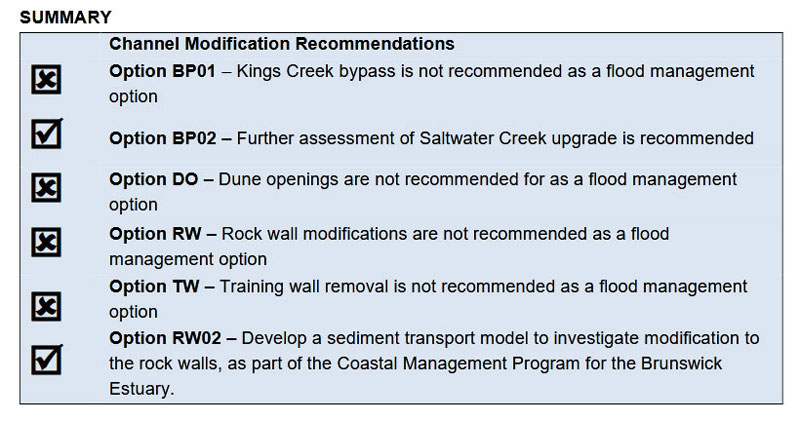
Above recommendations: taken from the Final North Byron Floodplain Risk Management Plan (October 2020)Questions for Flood Data Modellers 2022 in relation to the NBFRMP October 2020:
A modeller is someone who makes theoretical descriptions of systems or processes in order to understand them and be able to predict how they will develop.Question 7:
How can we lower the floodwater levels on Marshalls Creek Floodplain?
Comment: TBAQuestion 8:
Where does the floodwater flow and pond on the Marshalls Creek Floodplain?
Comment: Flood Flow - Flood PondingQuestion 9:
Why haven't we re opened the flood overflow outlets?
Comment: TBAQuestion 10:
Can the excess floodwater be removed from the floodplain by pumping it directly into the ocean at strategic locations along the coastline?
Comment: Flood Flow - Flood Ponding_________________________________________________________________________________
Greater Ocean Shores Flood Prevention & Mitigation Group:
click here to access map
Documents and Photo FACTS
compiled by
Jim Mangleson
Foundation Community Representative of the
Marshalls Creek Flood Plain Management CommitteeHistorical FACTS Researched by
The late Frank Mills OAM
Former Chairman of OSCA Inc.
Committee Representative for BV Historical Society
Representative on the Abi Group - Member of the Heritage Management PlanPhotos & additional documentation
Frank Mills
Reg Burns
Judy AnningSupported by OSCA Inc.
Ocean Shores Community Association Inc.
Registration Inc. Y1833127 ABN:81 081 151 216
Building Community in Ocean Shores since 1970
Key
documents
TIMELINE
1974
North Ocean Shores
Flood Outlet
Click
here
1976
BSC Engineer's
Report
Click here
1982
Ferguson DP
letter to Council
Click
here
1984
Dept
Public
Works Letter
Click
here
1985
Letter to OS
Developers
Click
here
1986
Planning Powers
News Article
Click here
1986
Summary of the
issue at BSC
Click
here
1986
*Public Version
Cranston Report
Click
here
1986
*Council Version
Cranston Report
Click here
1990
Bond Bridge
Letter
Click
here
1991
Shire Engineer letter
Click here
1992
Letter of Concern
MCFPC
Click here
1997
MCFPC Amended
Plan
Click
here
1997
Re-vegetation
Natural Outlet NB
Click here
2005
Letter to The Hon
Kerry Hickey MP
Flood Rainfall Data
Click
here
2005
Flood Meetings
Summary OS & SGB
Click here
2005
Flood Meetings
Ocean
Shores
South
Golden Beach
2005
Cross
Section
Helen St 2005
2006
February 3
Letter to The Hon
Frank Sator MP
Click
here
2006
April 27
Letter received
Director General, Dept of Natural Resources
Click
here
2008
November
Culverts added
to Bund
Click
here
2020
OSCA replay to
NBFPRM Plan
Click
here
objection responses.
Website Provider Disclaimer. While every effort has been made to ensure the information on this site is correct, it is not always possible to achieve complete and total accuracy.
Therefore we accepts no responsibility for any loss or damages which may occur to any persons as a result of information obtained from this site.


