Marshalls Creek Floodplain - COMMUNITY EDUCATION - LOCAL STORIES
![]()


Marshalls
Creek
PPP Slide Images
Images will 'pop up'
on click
Slide
00
Title
Slide
Slide
01
Flood
Mitigation
Strategy
Slide
02
Pre
Development
- BILLINUDGEL
Slide
03
Post
Development
- BILLINUDGEL
Slide
04
Billinudgel
Elevation Model
Slide
05
Ocean
Shores
Elevation Model
Slide
06
Pre
- Development
SGB / New Brighton
1947
Slide
07
Pre
- Development
SGB / New Brighton
1958
Slide
08
Pre
- Development
SGB / New Brighton
1962
Slide
09
Pre
- Development
SGB / New Brighton
1966's
Slide
10
Pre
- Development
SGB / New Brighton
1971
Slide
11
Pre
- Development
SGB / New Brighton
1987
Slide
12
Pre
- Development
SGB / New Brighton
2000
Slide
13
Flooding
at South
Golden Beach
Slide
14
Flood
Flow at
South Golden Beach
New Brighton
Slide
15
Flood
Mitigation
Strategies
Slide
16
Separate
Questions
Slide
17
Targeted
Strategies

3D
mapping image 2004 - NSW Department of Finance, Services and
Innovation - CLICK TO ENLARGE
COMMUNITY EDUCATION
To review the historical changes to the Marshalls Creek Floodplain and the potential impacts on flood flow please access information below.
Robert Crossley - Natural Resources Scientist
In association with OSCA Inc. & New Brighton Village AssociationThe document and the presentation by Robert Crossley is based on personal interpretation of the available aerial imagery since 1947, the stories of the local residents and the reports of scientific studies that have been produced in the past.
He does not profess to know all the answers, and is always open to be proven wrong by evidence. This document hopes to progress the conversation in improving the situation.Note from Rob: Since doing this video, I have learned some more from feedback from others and reflecting on what has been said. However, let’s use this video as a starting point for discussions to build our understanding and discuss potential solutions that we can lobby for. If you wish to ask questions or to make comment on what I have said (good or bad), Mark has set up a Facebook page that we can continue to this conversation https://www.facebook.com/MarshallsCreekFloodplain/ .
____________________________________________________________________________
CASE STUDY COMPONENT 1
Billinudgel Local Story & Observations:
View the video talks about Billinudgel.
Where did the water flow, and what has changed?
Take Home Messages
View presentation pages in relevant spots: see Slides 02, 03, 04 left column.
1. Flood water used to flow through a swampy area to the south of the village, and discharged back into Marshalls Creek to the east.
2. Development of the industrial estate closed the natural flow path, and flood water was channelled through man made drains.
3. Billinudgel suffered its worst flood in 2017, when the drains were badly clogged with vegetation and rubbish.
4. Drains were cleared after 2017 and Billinudgel was the only place where the flood in 2022 was not much worse than in 2017.
5. Drains are not being regularly cleared.____________________________________________________________________________
CASE STUDY COMPONENT 2
South Golden Beach Local Story & Observations:
View the video talks about South Golden Beach & New Brighton.
Where did the water flow, and what has changed?
Take Home Messages
View the presentation pages in relevant spots: see Slides 06, 07, 08, 09, 10, 11, 12, 13, 14 left column.
1. Historically, flood waters overflowed out of Marshalls Creek just to the east of the old highway and around the current location of Kolora Way into channels that discharged through an ocean outlet where Helen Street is now located.
2. Water from Billinudgel Nature Reserve also seemed to flow into the same outflow from the north.
3. This outflow was closed by developers prior to 1958.
4. Numerous attempts to limit the flooding in the South Golden Beach (SGB) development resulted in overflow water from Marshalls Creek ponding between SGB and New Brighton and then flowing back into New Brighton (NB) to flood the village:a. Construction of Capricornia Canal to link the water from the north and Marshalls Creek.
b. Fill at Kolora Way.
c. Levees constructed around SGB and closed ocean outfalls between South Golden Beach now pond water between SGB and New Brighton until it gets high enough to flow back into Marshalls Creek.
d. Water pumped from inside SGB back into the canal to add to the flood water.
5. A man-made canal/ocean outflow constructed by developers to the north of SGB in the 1970’s to divert water from the north entering SGB was closed by Council due to salt water incursion during high seas (note that there was never a natural outflow at this location).
6. It would seem logical that flooding in New Brighton and probably South Golden Beach could be minimal if the flood water that ponds between South Golden Beach and New Brighton could be discharged to the ocean instead of flowing back to re-join Marshalls Creek at New Brighton, as it did historically.____________________________________________________________________________
CASE STUDY COMPONENT 3
Ocean Shores Local Story & Observations:
View the presentation pages in relevant spots: see Slide 05 left column.
Little insight on flood process in Ocean Shores in the area near Waterlily Park is provided at this stage other than to note that the terrain model shows a pinch point in the drainage network that would be susceptible to failure if not maintained well.Take Home Messages
View the presentation pages in relevant spots:
TBA____________________________________________________________________________
CASE STUDY COMPONENT 4
Potential Flood Mitigation Strategies:
Please click here to access suggested solutions
____________________________________________________________________________CASE STUDY COMPONENT 5
Potential Flood Mitigation Strategies:
North Byron Sky Pump Proposal
Please click here to access suggested solutions
Provide us with your comments on the North Byron Floodplain Risk Management Plan (Oct 2020);
The North Byron Floodplain Risk Management Plan October 2020 (NBFRMP) has been finalised.
Please view the plan and provide us with your COMMENT via email or a POST on the Facebook page link below.
Please provide name, location, email and mobile in your email feedback.
...............................
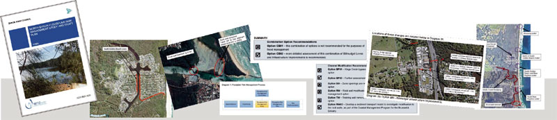


Snapshot of Key Points;
Draft
Review
Document
by Robert Crossley
Flood
Meeting
PPP Talk
Byron
Shire Council
Flood Studies
Marshalls
Creek
North
Byron
Floodplain Risk
Management Plan
- FINAL
Oct 2020
Marshalls
Creek
PPP Slide Images
Images will 'pop up'
on click
Slide
18
References
Slide
19
Impact
of
Dredging No 1 Model
Slide
20
Impact
of
Dredging No 2 Model
Slide
21
Overflow
Solutions
Slide
22
Case
Study
Solutions
Slide
23
Readings
Bay
Circa 1960's
Slide
24
Readings
Bay
Circa 2010
Slide
25
Previous
Flood
Studies & Reports
Slide
26
Flood
Ponding
Slide
27
Flood
Flow
Slide
28
SGB
1947
Slide
29
Readings
Bay 1960
Slide
30
Readings
Bay 2010
Slide
31
Readings
Bay
Rock Wall 2017
Slide
32
Readings
Bay
Sand Build Up
Slide
33
Flood
Overflow Gates
Slide
34
Ponding
& Flow Map
Slide
35
Call
to Action
Slide
36
OSCA
Flood
Meeting
Slide
37
North
Ocean Shores
Flood Outlet 1974
Slide
38
Byron
Shire Peak
Flood Levels 2050
Website Provider Disclaimer. While every effort has been made to ensure the information on this site is correct, it is not always possible to achieve complete and total accuracy.
Therefore we accepts no responsibility for any loss or damages which may occur to any persons as a result of information obtained from this site.