Flood History Facts ... Greater Ocean Shores Flood Prevention & Mitigation Summary
![]()
HOME
![]()
Research
information
taken from;
2017
NOM
9.4
Byron Shire Council
April
2022
Community
Flood Meetings
June
2022
Marshalls
Creek
Floodplain Review
August
2022
Investigation
Flood History
Documents
December
2022
Synopsis
Summary
December
2024
NBSFM
Case Study
February
2026
Flood
Meeting
Proposal
Understanding
the local
flood history
1947
Coastal
View from
Brunswick Heads
River to Wooyung
1974
North Ocean Shores
Flood Outlet
Click
here
2022
Greater
Ocean Shores
Investigation Map
Summary
Case
Study
Belongil Creek
Byron Bay
Case
Study
Solutions
'It is not rocket science'
A synopsis is a brief summary which gives readers an overview of the main points.
Synopsis Brief:
After reviewing all the available information on the flood history of Marshalls Creek Floodplain, we have now summarised the main points as we see it.
Our aim is to provide the community with an online research portal to enable individuals to access relevant information on the flood mitigation strategies for the Marshalls Creek Floodplain. This portal allows local residents to research, communicate, plan with evidence and monitor the decision making process through Byron Shire Council, State & Federal Government.Tasks:
1. Investigate further the flood history documents and historical timeline facts of the establishment of the Ocean Shores Estate.
2. Identify the natural flood overflow locations along the coastline from Wooyung to the mouth of the Brunswick River.
3. Identify the legal obligations of Council to provide a ‘duty of care’ for those residents living on the Marshalls Creek Floodplain.
4. Identify possible flood mitigation strategies to lower the flood levels on the Marshalls Creek Floodplain and along the coastline from Wooyung to Brunswick Heads.CASE STUDY COMPONENTS:
1. Deed of Agreement for the construction of the Ocean Shores Estate flood outlet.
2. Environmental Impact on closing the outlet.
3. Liability for the flooding of surrounding villages.click here to access The Report Part 1.
click here to access Restoration Project Part 2.
click here to access The Restoration Project PPP.Synopsis webpage and information
The four (4) main points we have covered in this synopsis are listed below;
Main Point 1.
FLOOD HISTORY TIMELINE of EVENTS - Reserach
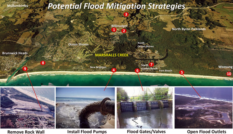
Please access the links on this page to view the documents that have been gathered from a number of individuals and community organisations. We encourage you to formulate your own opinions, as to what has contributed to the flooding issues, on the Marshalls Creek Floodplain.Observation: With the closure of the original flood overflow outlets to the ocean from Wooyung to Brunswick Heads, there is now nowhere for the flood water to go except into our homes and businesses. These outlets provided natural flow of the creek water, as well as to allow an increase in water volume to escape during severve rain events. These outlets have been deliberately closed. The area behind the sand dunes acts like a dam which exacerbates the flooding situation. The excess floodwater needs to be allowed to escape or taken off the floodplain directly into the ocean at different access points along the coastline. It appears the creation of the artificial sand dunes in the 1930's to 1960's was well intentioned, but have largley contributed to the flooding issues on the floodplain. It was noted from the Byron Bay and Brunswick Valley Historical Society that sand mining was conducted along the coastline from 1934 - 1968. The map below profiles the 'flood hotspots' on the floodplain providing a clear overview of the current flooding issues.
* Read also NBFRMP 2020 below Sections 11.4.3, 11.4.10___________________________________________________________________________________________

Main Point 2.
COMMUNITY INVOLVEMENT & FEEDBACK - Communicate
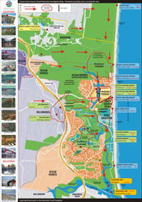
Please access the map below to view the information compiled from a number of individuals and community organisations. The map provides a summary of the flood mitigation strategies. This map also showcases the floodwater flow and ponding on the floodplain as we understand it.Observation: We have used a scaled map of the Greater Ocean Shores area in order to create a more accurate and realistic summary of the flooding issues and their location on the floodplain.
Please let us know if we have missed any important flood mitigation strategies or information.
Community Consultation Process
2a. OSCA Flood Meetings at Ocean Shores on April 6 & May 10, 2022
Facilitated by North Byron Activation Community Flood Response.
Correspondence: Newsletters and updates via email, Facebook page.
Meeting video link click here2b. CSIRO Workshop at Ocean Shores on Wednesday Nov 4, 2022
2c. Belongil Creek - Byron Bay NSW
Case Study SolutionsClick on map below to enlarge
Investigation Map supplied by OSCA Inc.
____________________________________________________________________________________________

Main Point 3.
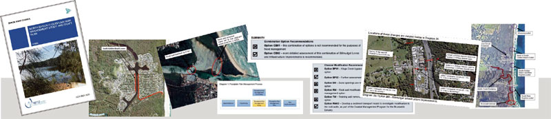
FLOOD RISK MANAGEMENT PROCESS - Plan with Evidence
Byron Shire Council has a number of advisory committees set up to assist in the planning processes. One being the Audit, Risk and Improvement Committee (ARIC).The objective of the Audit, Risk and Improvement Advisory Committee is to provide professional, independent advice and assistance to Council in assessing the organisation's audit, compliance, risk and improvement performance.
Observation: Utilising all the resources and expertise available to Council would allow for a more effective decision making process.
COMPONENT 1:
The role of the Audit, Risk and Improvement Committee (ARIC Byron Shire Council).
Byron Shire Council website link click here .Correspondence: Letter from concerned resident to Cr Alan Hunter (ARIC Member - Byron Shire Council).
ARIC Constitution
To access pdf version of the ARIC Constitution click here.
NOTE: One of the 9 Primary Functions of the Audit, Risk, Improvement Committee at Byron Shire Council is to ensure that:
No 2. Appropriate risks and exposures are identified and effectively managed;ARIC Constitution 5.2 on Risk Management
a) Review whether management has in place a risk management framework that complies with current Australian risk management standards.
b) Review whether the risk management framework operates effectively and supports the achievement of Council’s strategic goals and objectives.
c) Review whether management has integrated risk management into decision making processes and operations.
d) Review whether management has taken steps to embed a positive risk management culture.
e) Consider the adequacy of resources provided for risk management and whether employees are able to carry out their risk management responsibilities.COMPONENT 2:
The role of the Marshalls Creek Floodplain Advisory Committee to Byron Shire Council.
The purpose of the Floodplain Management Advisory Committee is to oversee and advise Council on the preparation, implementation and review of Flood Studies and Floodplain Risk Management Studies as required.
The FLOODPLAIN RISK MANAGEMENT PLAN for Byron Shire Council;
FINAL - North Byron Floodplain Risk Management Plan October 2020
The North Byron Floodplain Risk Management Plan October 2020 (NBFRMP) has been finalised.
Complete Document on Byron Shire Council website - click here
Observation: There needs to be more transparency and feedback to the community from the Marshalls Creek Floodplain Advisory Committee. This could be achieved through Community Education Meetings held 4 times throughout the year.
Marshalls Creek Floodplain Advisory Committee to Byron Shire Council;
Community Representative
Rebecca Brewin (Billinudgel)
Steven Harris (Mullumbimby)
Karl Allen (Mullumbimby)
Matthew Lambourne (Main Arm)
Robert Crossley (New Brighton)
Catherine Lane (SGB)
Duncan DeyByron Shire Council Staff & Councillors
Scott Moffett (BSC Flood and Drainage Engineer)
Phil Holloway (BSC Director of Infrastructure Services)
James Flockton (Coordinator Infrastructure Planning)
Chad Ellis (SES)
Cr Coorey (Councillor)
David Warth (Councillor)____________________________________________________________________________________________
Main Point 4.
DECISION MAKING PROCESS - Monitor
Current Minutes of Flood Advisory Committee meeting
(Access in the dropdown MEETING icon Floodplain Management Advisory Committee then click APPLY) - click hereObservation: There are two ways to access the agendas and minutes.
1. Select HTML to view a web page version. Choose the item you are interested in using the contents on the left hand side of the page. Individual attachments can also be downloaded.
2. Select PDF to download a copy to your own device. Council Meeting Agendas include a link to each attachment, which can be downloaded separately by selecting the PDF icon.
The PDF for committee meetings includes a non-searchable version of the attachments. This allows for committee members to print the full document if required. To download committee meeting attachments separately, use the HTML version.Click on icon below to access Byron Shire Council Minutes
____________________________________________________________________________________________
To have a say ... please access our Facebook page at https://www.facebook.com/FloodHistory/Email us: Click here
Observation: Everyone has a right to be heard. By listening to all residents, a bigger picture of flood mitigation strategies can be formulated for future planning purposes.Correspondence: Letter from concerned residents to Mayor Cr Michael Lyon February 2023.
____________________________________________________________________________________________
Some interesting facts and documents from the flood history archives;
Deed of Agreement:
The Deed of Agreement was the founding document of the town. It outlined an agreement with the NSW State Government, Byron Council, Rous County Council (water), the Municipality of Mullumbimby (electricity provider) the owners of the dairy farms who sold their properties and Wendell West Australia Pty Ltd (the developer). Over a period of 25 years the town was to be developed in three stages. Wendell West sold its Australian interests to Princess Properties Pty. Ltd who took over as the developer of the project.Question: Was the original 'condition of approval' by the Public Works Department to include a flood overflow outlet for the development of the Ocean Shores Estate, ever undertaken?
KEY DOCUMENTS & REPORTS:
1. Shire Engineers Report 1976.
Council records provided by Ombudsman showing Council resolution to accept liability for flooding caused by the company complying with Council's request to close the temporary flood outlet situated north of the site now known as Fern Beach.
Click here to view original document.
2. Deputy Premier Ferguson's letter to Council 1982.
Letter from the Deputy Premier & Public Works Department to Byron Shire Council certifying that the development of residential areas in the north of the shire was approved subject to an ocean outlet being constructed and maintained.
Click here to view original document.3. Shire Clerk C.J. Shevellar's letter to the Ocean Shores Developers 1985.
A quick perusal of Council's files showed 7 letters from 1973 to 1985 addressing the issue of installing the flood overflow outlet to assist in controlling the flood levels.
Click here to view original letter.4. Frank Cranston's report to Byron Shire Council 1986.
After Jim Waugh was appointed Planning Administrator of BSC in 1986, he appointed an acting manager Mr Ray Rawson who engaged Fran Cranston to investigate all planning issues associated with the development of the Ocean Shores Estate which was covered by a Deed of Agreement.
Click here to view Council's version of the report on flood outlets p 52.


Make a COMMENT
![]()
Key documents
TIMELINE
1974
North Ocean Shores
Flood Outlet
Click
here
1976
BSC Engineer's
Report
Click here
1982
Ferguson DP
letter to Council
Click
here
1984
Dept
Public
Works Letter
Click
here
1985
Letter to OS
Developers
Click
here
1986
Planning Powers
News Article
Click here
1986
Summary of the
issue at BSC
Click
here
1986
*Public Version
Cranston Report
Click
here
1986
*Council Version
Cranston Report
Click here
1990
Bond Bridge
Letter
Click
here
1991
Shire Engineer letter
Click here
1992
Letter of Concern
MCFPC
Click here
1995
Value Management
Study on Outlets
Click
here
1997
MCFPC Amended
Plan
Click
here
1997
Re-vegetation
Natural Outlet NB
Click here
2005
Letter to The Hon
Kerry Hickey MP
Flood Rainfall Data
Click
here
2005
Flood Meetings
Summary OS & SGB
Click here
2005
Flood Meetings
Ocean
Shores
South
Golden Beach
2005
Cross
Section
Helen St 2005
2006
February 3
Letter to The Hon
Frank Sator MP
Click
here
2006
April 27
Letter received
Director General, Dept of Natural Resources
Click
here
2008
November
Culverts added
to Bund
Click
here
Website Provider Disclaimer. While every effort has been made to ensure the information on this site is correct, it is not always possible to achieve complete and total accuracy.
Therefore we accept no responsibility for any loss or damages which may occur to any persons as a result of information obtained from this site.