History of the Marshalls Creek Flooding
Menu
LATEST
UPDATES
MEDIA FILES
Video Stories
Channel Nine
News
1987
Charlie
O'Donnell
1984 Interview
WEATHER INFO
weather
radar
B.O.M.
tide
charts
B.O.M.
Why
was the June 2005 flood levels on Capricornia
Canal the highest ever
?
Was this a 1 in 500 year flood or not ?
The
present day flood crisis in the Brunswick Valley can be traced back
to two key documents dated 1976 and 1982.
Document 1. (1976)
Council records provided by Ombudsman showing
Council resolution to accept liability for flooding caused
by the company
complying with Council's request to close the temporary flood
outlet situated north of the site now known as Fern Beach.
click
here to view original document
Document
2. (1982)
Letter from the Deputy Premier to Byron Shire Council certifying
that the development of residential areas in the north of the shire
was approved subject to an ocean outlet being constructed and maintained.
click here for original document
" The
flooding problem of the North Arm is compounded by Ocean Shores Estate.
It is of concern to me that the conditions of my Department's concurrence
to the Ocean Shores Project have not been enforced by Council. The
flood assessment for the development was made on the basis that an
ocean outfall would be provided to reduce flood levels in the area, and the first stages of the development were approved subject
to the outfall being constructed and maintained.
The temporary outfall which was constructed is and has been for sometime ineffective due to road construction and dune stabilisation across the outfall mouth. Consequently, it is likely that existing residential development and any currently being approved on the lower parts of the estate is flood liable. This is contrary to the principles of sound flood plain management as enunciated in the Government's Flood Prone Lands policy and Council is likely to be in an invidious position in the event of flooding and damage to property. Council would therefore be well advised to undertake immediate remedial measures to alleviate this situation."
Letter received
by Byron Shire Council from
Laurie J Ferguson
Deputy Premier & Minister for Public Works & Ports
December 8, 1982
Original letter
1982
The
'7 Warnings' Letter 1985 -
outlined by Council to the Ocean Shores Developer.
" The position is, as explained by Mr. McDonald, that the development
currently existing was originally approved by Council and the Public
Works Department on the basis of a floodway design that incorporated
a flood overflow as an integral component in controlling the flood
levels. Subsequent development has proceeded at levels based on the
assumption that the flood overflow would be installed."
" A
quick perusal of Council's files has provided the following in support
of Council's viewpoint in this matter."
Full letter document from the Shire Clerk Mr C.J. Shevellar
1985.
PRESS
RELEASE July
1987 -
from the then Minister for Planning and Environment Mr Bob Carr.
'Carr removes wetland status'
The following statement was backed up by a spokeman for Mr Carr who
said a recent revision had shown that 33 hectares of the land was non-wetland
cypress pine and old marsh pastures.
"It never really was wetlands and shouldn't have
been included in the policy in the first place."
Full Newpaper Article from the Sydney Morning Herald
July 1987
Press
Story Northern Star September 1995 -
Proposed Options outlined...
"Dredging of Marshalls Creek, reopening ocean outlets
and modifying the Kallaroo Circut bund have been proposed as a solution
to flooding
in the north of the Byron Shire."
Full Newspaper
Article from the Northern Star September
1995
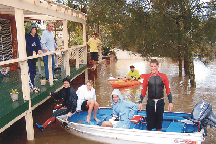
The Flood of June 2005 - Highest levels of flooding and water damage ever experienced by residents on the Marshall's Creek Flood Plain.
What will happen in the future ? Do we sit and wait for the next flood ? Or is it time to re think and re plan ?
click
on icon above
Latest Flood Information
as at April, 2017
Key
documents
TIMELINE
Council
Minutes 1976
Engineer's Report
DP's
letter 1982
Ferguson
to Council
Council
letter 1985
to OS Developers
Planning
Powers 1986
News Article
Summary letter 1986
re Council
situation
Cranston
Report 1986
Public Version
Cranston
Report 1986
Council Version
Council
Letter 1990
Bond Bridge
Council
Letter 1991
Shire Engineer
Letter to
Council 1992
Concern with MCFPC
Adopted
Plan 1997
MCFPC Amended Plan
Re-vegetation
1997
Natural Outlet NB
Flood Meetings
2005
Summary OS & SGB
Flood Meetings
2005
Ocean Shores
South Golden
Beach
Document and Photo FACTS
compiled by
Jim Mangleson
Foundation Community Representative of the
Marshall's Creek Flood Plain Management Committee
Historical
FACTS Researched by
Frank Mills OAM
Former Chairman of OSCA Inc.
Committee Representative for BV Historical Society
Representative on the Abi Group - Member of the Heritage Management Plan
Website
Brunswick Valley
Promotions 2005
Definition
of TRUTH: (Pocket Macquarie Dictionary)
1.
something which is true or actual: to tell the truth.
2. agreement with fact or reality: the truth of a statement
3. an indisputable fact, principle, etc: mathematical truths
4. genuiness, reality, or actual existence.
5. honesty or integrity.
6. in truth, in fact, in reality; truly.
Supported
by OSCA
Ocean Shores
Community Association Inc.
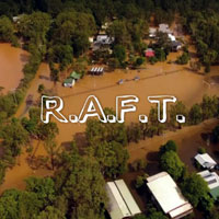
in asscoiation with R.A.F.T.
Residents Against Flood Turmoil
'Bring the river back to life !'
Website Provider Disclaimer. While every effort has been made to ensure the information on this site is correct, it is not always possible to achieve complete and total accuracy.
Therefore we accepts no responsibility for any loss or damages which may occur to any persons as a result of information obtained from this site.