Flood History Facts ... Greater Ocean Shores Flood Mitigation & Restoration Summary
![]()
HOME
![]()
Research
information
taken from;
2017
NOM
9.4
Byron Shire Council
April
2022
Community
Flood Meetings
June
2022
Marshalls
Creek
Floodplain Review
August
2022
Investigation
Flood History
Documents
December
2022
Synopsis
Summary
December
2024
NBSFM
Case Study
**February
2026
Flood
Meeting
Proposal
Understanding
the local
flood history
REAL LIFE v's DATA MODELLING
to be discussed.
Flood Mitigation & Restoration Project
A 'DUTY of CARE' to keep the community safe!
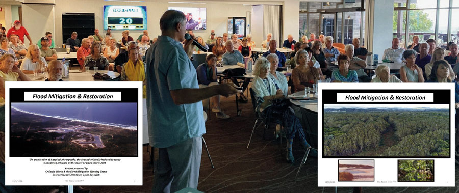
Cr David Warth speaking at the community flood meeting held at Ocean Shores Country Club on Feb 16, 2026.Project TASK:
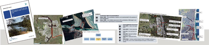
After reviewing the available information on the flood history in the north of Byron Shire, a proposal is being prepared to present to Byron Shire Council. This covers the area to the north of Fern Beach extending into Billinudgel Nature Reserve. We consider this area has considerable potential for flood mitigation and coastal environmental restoration. This area previously has not been adequately researched.Please view the content of the Flood Mitigation & Restoration presentation which was presented at the community flood meeting held at Ocean Shores Country Club on Monday February 16, 2026.
click here to access The Flood Mitigation & Restoration Project PPP.
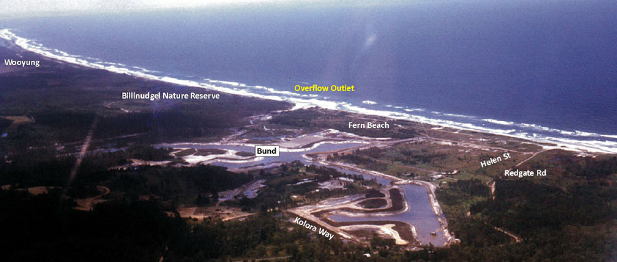
Photo of coastline from Wooyung in the north to South Golden Beach in the south.
(Flood overflow outlets have been identified to have existed at Wooyung, North Ocean Shores and South Golden Beach)Our aim is to provide the community with an online research portal to enable individuals to access relevant information on the flood mitigation strategies for the Marshalls Creek Floodplain. This portal allows local residents to research, communicate, plan with evidence and monitor the decision making process through Byron Shire Council, State & Federal Government.
Tasks:
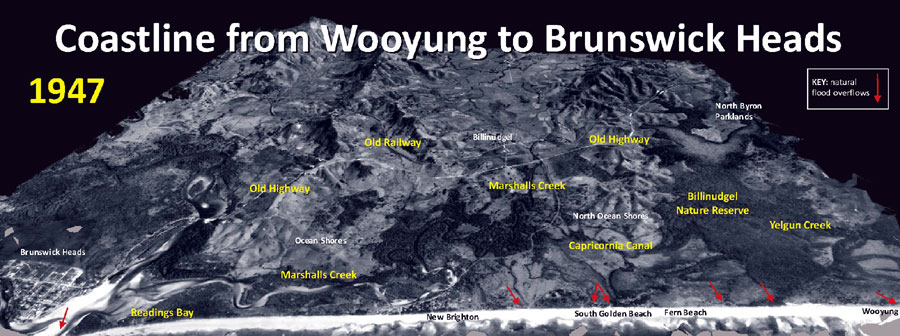
1. Identify the natural and man-made flood overflow outlets (low points) locations along the coastline from Wooyung to the mouth of the Brunswick River.
2. Identify the obligations of Council to provide a ‘duty of care’ for those residents living on the Marshalls Creek Floodplain.
3. Identify possible flood mitigation strategies to lower the flood levels on the Marshalls Creek Floodplain and along the coastline from Wooyung to Brunswick Heads.
4. Seek professional advice and information from qualified personnel in formulating a plan to identify effective flood mitigation strategies that will work.
5. Investigate the additional fill on the floodplain.-------------------------------------------------------------------------------------------------------
Selected research material from the Flood History Library of information;
Current documents and reports from community personnel and research groups;
1. Pre 2022 Community Obsevations and Reports on major floods from 1974 - 2025.
2. 2022 community observations, videos and reports on the February 2022 major flood.
3. Post 2022 comments and summaries from qualified personnel about possible flood mitigation measures that would help the area.-------------------------------------------------------------------------------------------------------
RESTORATION PROJECT COMPONENTS:
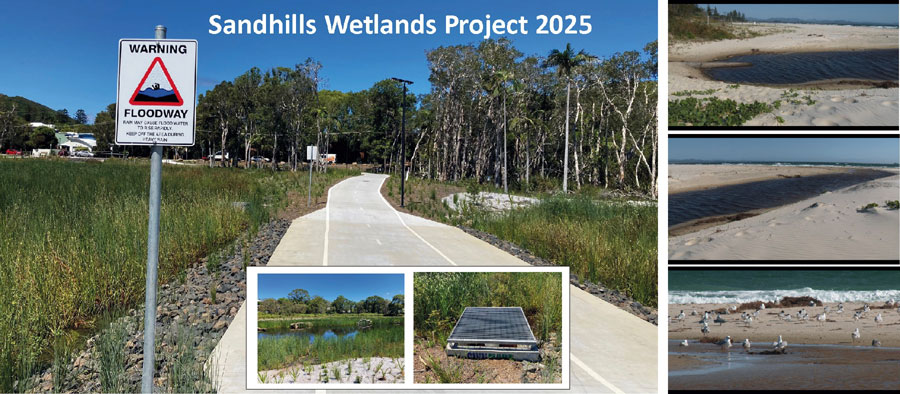
1. Blueprint / Case Study Model - Sandhills Wetlands Project 2025.
click here to view the Byron Shire Council project information.2. Community Support for Project.
Click here to register to receive information.3. Community Expertise and Monitoring Group.
-------------------------------------------------------------------------------------------------------
A Duty of Care;
COMMUNIITY INFORMATION ...
FLOOD RISK MANAGEMENT PROCESS - Plan with Evidence
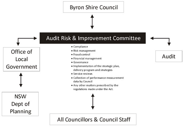
Byron Shire Council has a number of advisory committees set up to assist in the planning processes. One being the Audit, Risk and Improvement Committee (ARIC).The objective of the Audit, Risk and Improvement Advisory Committee is to provide professional, independent advice and assistance to Council in assessing the organisation's audit, compliance, risk and improvement performance.
Observation: Utilising all the resources and expertise available to Council would allow for a more effective decision making process.
COMPONENT 1:
The role of the Audit, Risk and Improvement Committee (ARIC Byron Shire Council).
Byron Shire Council website link click here .ARIC Constitution
To access pdf version of the ARIC Constitution click here.
NOTE: One of the 9 Primary Functions of the Audit, Risk, Improvement Committee at Byron Shire Council is to ensure that:
No 2. Appropriate risks and exposures are identified and effectively managed;ARIC Constitution 5.2 on Risk Management
a) Review whether management has in place a risk management framework that complies with current Australian risk management standards.
b) Review whether the risk management framework operates effectively and supports the achievement of Council’s strategic goals and objectives.
c) Review whether management has integrated risk management into decision making processes and operations.
d) Review whether management has taken steps to embed a positive risk management culture.
e) Consider the adequacy of resources provided for risk management and whether employees are able to carry out their risk management responsibilities.
-------------------------------------------------------------------------------------------------------
COMPONENT 2:
The role of the Marshalls Creek Floodplain Advisory Committee to Byron Shire Council.
The purpose of the Floodplain Management Advisory Committee is to oversee and advise Council on the preparation, implementation and review of Flood Studies and Floodplain Risk Management Studies as required.
The FLOODPLAIN RISK MANAGEMENT PLAN for Byron Shire Council;
FINAL - North Byron Floodplain Risk Management Plan October 20201. The North Byron Floodplain Risk Management Plan October 2020 (NBFRMP) has been finalised.
Complete Document on Byron Shire Council website - click here
2. The Tweed Byron Coastal Creeks Flood Study 2010
3. The Marshalls Creek Floodplain Management Report 1997 (Full)Marshalls Creek Floodplain;
Click here to access more information.Byron Shire Council Flood Meeting Minutes and Agendas;
Click here to access the minutes and agendas.Observation: There needs to be more transparency and feedback to the community from the Marshalls Creek Floodplain Advisory Committee. This could be achieved through Community Education Meetings held 4 times throughout the year.
Marshalls Creek Floodplain Advisory Committee to Byron Shire Council;
Note: Ocean Shores Community (OSCA Inc.) does not have a representative on this committee.
Community Representative
Matthew Lambourne (Main Arm)
Robert Crossley (New Brighton)
Catherine Lane (SGB)
Duncan Dey (Main Arm)
1 Dept of Planning, Industry and Environment Representative
1 State Emergency Services Representative Representative
1 Cape Byron Marine Park Representative Representative
1 National Parks Representative RepresentativeByron Shire Council Staff:
BSC Flood and Drainage Engineer
BSC Director of Infrastructure Services
Coordinator Infrastructure Planning
SES
Byron Shire Councillors:
Cr Elia Hauge (Councillor)
Cr David Warth (Councillor)
Cr Delta Kay (Councillor)
Cr Michael Lyon (Councillor)

Make a COMMENT
![]()
REGISTER
HERE
or
Scan qrcode 
to
receive
updates.
Key
documents
PLANNING
click
here
2024
The Report Part 1.
click here
2025
Restoration Project Part 2.
click
here
2026
Meeting Overview
click
here
2026
Flood Mitigation
Restoration PPP
click
here
2026
NOM 9.1
March 19, 2026
Research Data
1947
Coastline
Aerial
1989
Brunswick
River
Investigation
2000
NPWS
Managment Plan
2009
Tweed
Coastal
Creek Study
Website Provider Disclaimer. While every effort has been made to ensure the information on this site is correct, it is not always possible to achieve complete and total accuracy.
Therefore we accept no responsibility for any loss or damages which may occur to any persons as a result of information obtained from this site.